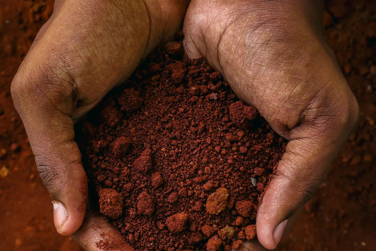
Most of the ground under Tyler is not the black, deep-cracking clay that so much Texas foundation advice is written about. The official soil survey of Smith County maps most of the county’s uplands as sandy or loamy soils over clay-enriched subsoils, many of them red. That is good news with a catch: the same survey names shrink-swell as a limit on building sites for several of the county’s most common soils. Van Zandt County and western Henderson County have far more of it.
Is Tyler built on expansive clay?
Mostly no, but not zero. By our tally of the survey’s acreage table, Ultisols make up about 40% of Smith County and Alfisols about 39%. Both are weathered soils with sandy or loamy surfaces over clay-enriched subsoils. Vertisols, the deep-cracking clay soils typical of the Blackland Prairie, cover only about 2.5%, all on the Sabine River floodplain.
The survey is the Soil Survey of Smith County, Texas, issued by the USDA Soil Conservation Service in July 1993 (our tally uses today’s NRCS soil classes). It splits the county into eight general soil map units:
| General soil map unit | Share of county | What the survey says about building on it |
|---|---|---|
| Wolfpen-Pickton (sandy) | 30% | Called “suited to most urban uses.” No shrink-swell limit found. |
| Bowie-Cuthbert-Kirvin | 18% | Called “suited to most urban uses,” but shrink-swell is named for Bowie (“moderate”) and for Cuthbert. |
| Redsprings-Cuthbert-Elrose | 17% | Red, ironstone-rich soils. Shrink-swell is named for the Cuthbert soils. |
| Lilbert-Darco-Tenaha (sandy) | 14% | No shrink-swell limit found. |
| Oakwood-Cuthbert | 11% | Oakwood is “suited to most urban uses.” Shrink-swell is named for Cuthbert. |
| Mantachie (stream floodplains) | 6% | The survey says the unit is “not suited to cropland or urban uses because of the flooding and the wetness.” |
| Gladewater-Estes (Sabine River floodplain) | 3% | The survey says these soils are “not suited to crops or urban uses.” Shrink-swell is among Gladewater’s limits. |
| Freestone-Oakwood | 1% | The smallest unit. |
Cuthbert is the most widespread single soil in the county, at about 17%, followed by Wolfpen at about 11% and Pickton at about 10%. Cuthbert is the one to know. The survey describes its typical subsoil as “very firm, very strongly acid, red clay” starting about 6 inches down.
Where the survey flags shrink-swell
The survey’s glossary puts the term plainly: “Shrink-swell. The shrinking of soil when dry and the swelling when wet. Shrinking and swelling can damage roads, dams, building foundations, and other structures. It can also damage plant roots.”
It then names shrink-swell as a building-site limitation for several upland soils:
- Bowie: “The wetness and the moderate shrink-swell potential are limitations on building sites.”
- Cuthbert: “The slope and the shrink-swell potential are limitations on building sites.”
- Kullit: “The shrink-swell potential is a limitation on sites for building foundations. Good design and proper installation are needed to overcome these limitations.”
- Sacul: “The shrink-swell potential is a limitation on sites for dwellings.” Sacul is rare here, about 0.3% of the county.
We found no shrink-swell limit in the survey text for the sandier soils (Wolfpen, Pickton, Lilbert, Darco, Tenaha) or for Oakwood, though “not found” in a scanned survey is not a promise. So shrink-swell risk in Smith County changes from lot to lot with the subsoil: low on the deep sands, flagged on the red clay subsoils and on Bowie. That is lower and patchier than on Blackland clay, but it is not zero.
The survey also flags corrosion: Kirvin soil in built-up areas “has a highly corrosive effect on uncoated steel and concrete.” If a company proposes steel piers, ask how the steel is protected.
What lies under the soil in Smith County?
Mostly sand formations. The survey says “The entire county is underlain by formations of Eocene age,” and that the Queen City Sand “outcrops in more than two-thirds of the county.” A ring of shale and green-brown sandstone, the Weches Formation, carries the county’s red, iron-rich soils.
The survey’s geology section, in plain terms:
- The Tyler Basin. “The major geologic feature is the Tyler Basin, which is a troughlike depression trending north-northeast and centered near Tyler.”
- Queen City Sand, 0 to 700 feet thick, under more than two-thirds of the county. Its main soils are Cuthbert, Oakwood, Pickton and Wolfpen in the west and Bowie, Cuthbert, Darco and Lilbert in the east.
- Weches Formation, a thin, circular belt around the Sparta Sand that “forms small cuestas or escarpments.” Its main soils are Elrose and Redsprings, and Redsprings can have “Ironstone fragments 1/2 inch to 3 inches thick and 3 to 20 inches across” on or in the surface.
- Sparta Sand, which “covers approximately 20 percent of the county” in the central part.
- Carrizo Sand, in small areas in the northwest and southeast.
For a homeowner, the point is how fast the ground changes. Houses a short drive apart can sit on different formations and different soils, which is why a county map is a starting point, not a diagnosis.
How do Van Zandt, Henderson and Cherokee counties compare?
They differ a lot. About 63% of Van Zandt County is in soil units whose limits include shrink-swell, mostly rated “high”. Henderson County splits in two: sandy soils in the east and shrink-swell soils across about 32% of the county, mostly west-central. Cherokee County’s latest survey dates from 1959.
| County | Latest survey | What it shows |
|---|---|---|
| Smith | July 1993 | Ultisols about 40%, Alfisols about 39%, Vertisols about 2.5% (Sabine floodplain only). Shrink-swell named for several upland soils. |
| Van Zandt | March 1998 | About 63% in units whose limits include shrink-swell. Sandy or loamy upland units about 26%. |
| Henderson | November 1979 | Sandy Pickton-Wolfpen unit 45%. Units whose limits include shrink-swell about 32%. |
| Cherokee | March 1959 | Bowie-Lakeland-Eustis about 41%, Nacogdoches-Magnolia-Bub 25%, Boswell-Susquehanna 18%, Tuka-Bibb 16%. |
The 63% and 32% figures are our sums of each survey’s unit percentages.
Van Zandt County
The Van Zandt survey describes a county that spans the “Western Coastal Plain, Texas Claypan Area, and Texas Blackland Prairie” land resource areas. Its largest unit, Woodtell-Freestone (39%), lists “very slow permeability, high shrink-swell potential, low strength, and wetness” as the major limits on urban development. For the Crockett unit (16%), “Shrinking and swelling are limitations affecting dwellings.” Edge (6%) and the Gladewater floodplain (2%) also list high shrink-swell.
Woodtell’s official series description shows what that looks like. The soil cracks when dry in the upper subsoil “during the summer months of most years,” with cracks up to about 1 inch wide and 10 to 20 inches or more deep. At the county level, Van Zandt sits closer to Blackland behavior than Smith County does. See the Canton page for the local permit rule, which names foundation repair.
Henderson County
The Henderson survey places the eastern half of the county in the East Texas Timberlands, the west-central part in the Texas Claypan and the far west in the Blackland Prairies.
The sandy Pickton-Wolfpen unit, 45% of the county, is rated medium for most urban uses. The Axtell-Freestone unit (17%) is another story: “Potential for most urban uses is low. Shrinking and swelling with changes in moisture, low strength, wetness, and corrosivity to uncoated steel are the most limiting features.” The Woodtell-Freestone unit (9%) carries the same warning. The Chandler and Athens pages cover two Henderson County towns.
Cherokee County
The latest Cherokee County manuscript we found was issued in March 1959. Soil names have been reclassified since. Boswell and Susquehanna, mapped together on about 18% of the county, are now classed as vertic Alfisols, like Van Zandt’s Woodtell, and we could not confirm how that land is mapped today. The Handbook of Texas adds that “Redlands cover a fourth of the county,” and the 1959 survey notes that “The sandy mesas are underlain by a stratum of brown iron-bearing ore.” Treat Cherokee’s picture, including around Jacksonville, as provisional.
Why does so much Texas foundation advice talk about clay?
Because much of Texas has it. The ASCE Texas Section’s repair guidelines say: “Texas has large areas with clayey soils that shrink and swell with changes in soil moisture content.” The classic example is Houston Black clay of the Blackland Prairie. Most of Smith County is different ground, so advice written for that clay fits Tyler only in part.
Houston Black is clay and silty clay from the surface down. Its official description records “High shrink-swell potential and cracks that are 1.3 to 10 cm (1/2 to 4 in) wide at 30 cm (12 in) depths during dry periods,” and places it in the Blackland Prairies of “East Central Texas.”
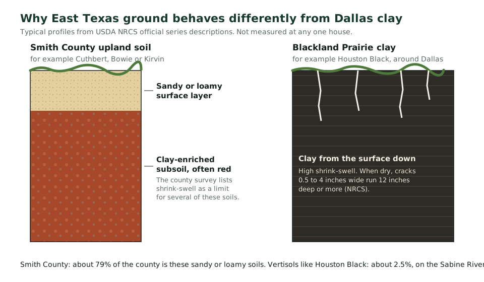
The NRCS also labels each soil’s clay minerals. Houston Black and Woodtell, both recorded as cracking when dry, are “smectitic”. Cuthbert, Smith County’s most widespread soil, is “mixed”, and Redsprings is “kaolinitic”. So the soil order alone can mislead: Woodtell is an Alfisol, like much of Smith County, yet it cracks when dry. Clay-heavy advice is right for the Blackland and much of Van Zandt County, and only partly right for Tyler.
When is the ground wettest and driest in Tyler?
Tyler averages 42.1 inches of rain a year, but not evenly. NOAA’s 1991 to 2020 normals put June (4.38 inches) and October (4.31) at the top and July (2.10) at the bottom. The driest stretch lines up with the hottest: the normal highs for July and August are 94.4°F and 94.9°F.
An average year brings 98 days at 90°F or more, and 14 days at 100°F or more.
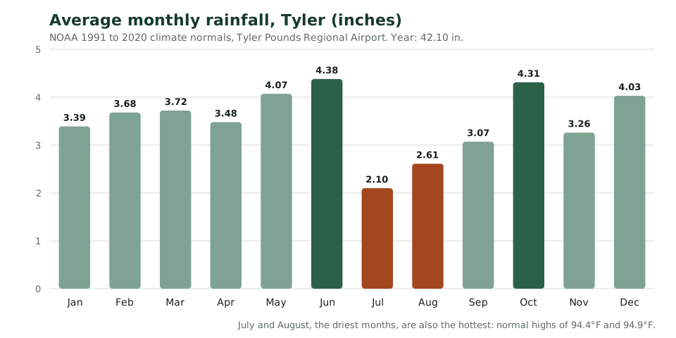
The survey’s definition ties shrink-swell to moisture: soil shrinks “when dry” and swells “when wet”. For Van Zandt’s Woodtell soil, the official description ties the cracks to “the summer months of most years.” If you are watching a crack in your own house, date every photo, so an engineer can see whether it changes with the seasons.
What did the 2011 and 2022 droughts look like here?
2011 was the extreme. The Tyler Pounds Field station recorded 25.00 inches of rain, 59% of normal, with 140 days at 90°F or more and a high of 110°F. The U.S. Drought Monitor showed exceptional drought over all of Smith County on 11 weekly maps in a row, from August 9 to October 18, 2011.
Writing in the Texas Water Journal, the Texas State Climatologist called it “unprecedented in its intensity” and noted that “By early fall, trees in central and eastern Texas were showing widespread mortality.”
| Year | Rain at Tyler Pounds Field | Share of the 42.10-inch normal | Days at 90°F or more | Hottest reading |
|---|---|---|---|---|
| Normal, 1991 to 2020 | 42.10 in | 100% | 98.1 (average) | Not applicable |
| 2011 | 25.00 in | 59% | 140 | 110°F |
| 2022 | 33.73 in | 80% | 120 | 107°F |
| 2023 | 33.18 in | 79% | 120 | 109°F |
2022 was sharp but short. At its peak, on the August 9 and 16 maps, extreme or worse drought covered about two-thirds of Smith County (65.44% and 67.32%) and exceptional drought 4.40%. By August 23, severe or worse drought was down to 6.61% of the county. For contrast, the wet year of 2015 brought 68.06 inches.
Dry years bring a second risk. When the Legislature weighed a license for foundation repair companies in 2011, the Senate committee’s bill analysis said: “Moreover, in light of Texas’ drought history, increasing numbers of predatory practices by underfunded but opportunistic repair companies have been reported.” The bill did not become law, and Texas still has no such license, so read how to check a foundation repair company before you sign anything.
What can you do around the house?
Manage water. The ASCE Texas Section guidelines call for ground that slopes away from the house, downspouts that empty well away from it and even soil moisture on all sides, with a caution against overwatering. They also warn that trees near a foundation “may cause soil shrinkage under the foundation.”
- Slope the ground. “a minimum slope of 5 percent (i.e. 6 inches in 10 feet) away from the foundation should be provided for the first 10 feet all around.” (section 7.3.5.1)
- Carry roof water away. “Downspouts should be extended well past the edge of the foundation, past the edge of abutting planting beds, and into well-drained areas.” (7.3.4)
- Keep downspouts out of French drains. “Downspouts and surface drains should not be connected to perforated pipe subsurface drainage systems.” (7.3.5.4)
- Mind big trees. “Trees or large shrubs near a foundation may cause soil shrinkage under the foundation.” (7.3.2)
- Water evenly, not heavily. The guidelines say “maintaining near uniform soil moisture conditions near all sides of the foundation may be beneficial”, but also that “Caution should be advised against excessive watering.” (7.3.1)
These are engineering guidelines, not law. Read your repair warranty too: Texas homeowners have posted about companies refusing warranty claims over “not watering” and because “Soaker hoses weren’t installed.” Drainage work has its own price ranges on our drainage correction page and in the cost guide.
How do you find out what is under your own house?
Start with the county survey, then get a professional look at your lot. The surveys map soils in broad units, and their depths are typical, not measured at your house. The ASCE Texas guidelines say evaluation and repair design “shall be performed by a professional engineer licensed in the State of Texas.”
All four county surveys are free to read as scans on the Internet Archive (see the sources below).
Texas engineering law has a rule aimed at this exact question. The usual exemption for work on a private dwelling does not cover engineering design for repairing “a residential dwelling slab located on expansive soil that meets the expansive soil classification provisions of the International Residential Code as applied in the jurisdiction in which the residential dwelling is located,” unless the work meets that code (Occupations Code §1001.056(c)(2)). We could not find a source that says which Tyler-area lots meet that classification, so ask the engineer. This is general information, not legal or engineering advice.
For who to call first, see engineer or foundation company and our page on foundation inspections. For the signs worth logging, see signs of foundation problems.
Before you hire anyone
Check the company yourself
Texas does not license foundation repair companies. Bills to create a license passed the Senate in 2011 and died in the House, and a second attempt in 2013 also failed (SB 1399, HB 613). So the checks that matter are yours to make. Each takes a few minutes.
- Ask who the engineer is. The Texas engineering board says working out why a foundation moved, or recommending how to repair it, is the practice of engineering (Advisory Opinion 43). Get the engineer's name and look up the license on the state roster.
- Check the plumber's license. If the job includes a plumbing test or a leak repair, the plumbing has to be done under a licensed plumber. Look the license up with the Texas State Board of Plumbing Examiners.
- Read the warranty before you sign. Get it in writing, see whether it transfers when you sell, and find the clauses that void it. Watering and plumbing conditions are the ones homeowners most often learn about too late.
- Ask who pulls the permit. Most cities here charge a permit fee for repairs, and Canton names foundation repair in its fee schedule. Unincorporated county land has no building permit at all. Our permit guide lists each office.
- Keep the paperwork. If a job goes wrong, Texas law makes you give the company written notice at least 60 days before you sue under the Deceptive Trade Practices Act (Bus. & Com. Code §17.505). Estimates, contracts, photos and emails are your record.
What happens after you call or send the form
- 1
Your request goes to one company
We pass it to one independent foundation repair company that works in your area. Not a list, and not an auction.
- 2
They call to set up a visit
Most Tyler-area foundation companies advertise a free inspection or estimate. Ask on that first call, so there are no surprises.
- 3
You get a written estimate
It should name the repair method, how many piers and where, who designs the repair, the permit, the warranty and the price. Compare it with our published price ranges.
- 4
You decide
There is no obligation. If you want a second opinion, an independent structural engineer's evaluation usually costs $300 to $800.
Soil and foundation questions
To prevent foundation damage you need to water foundation? Use soaker hose?
The ASCE Texas Section repair guidelines say “maintaining near uniform soil moisture conditions near all sides of the foundation may be beneficial” and also that “Caution should be advised against excessive watering.” That is a maybe, not a must. Ask the engineer or company whether your soil calls for it. If you have a repair warranty, read its watering clause: Texas homeowners have reported warranty claims refused over watering.
When to repair foundation - during or after current drought?
We found no official guidance on repairing during or after a drought. The ASCE Texas guidelines leave evaluation and repair design to a Texas-licensed engineer, and they warn that “It is unlikely that elevation adjustments will result in a level foundation.” Ask the engineer how the current soil moisture affects the readings, and keep the dated elevation survey so later readings can be compared with it.
What cities have LESS foundation problems?
We know of no published count of foundation problems by town. The soil surveys are the closest guide: most of Smith County’s uplands are sandy or loamy, while about 63% of Van Zandt County is in soil units whose limits include shrink-swell. Within any town, the soil can still change from lot to lot, so the county picture is only a starting point.
Which soil survey covers my county, and how old is it?
Smith County: July 1993. Van Zandt County: March 1998. Henderson County: November 1979. Cherokee County: March 1959, the only manuscript we found. All four can be read free as scans on the Internet Archive (links in the sources below). Soil names and classes have changed since some were printed, so treat the older surveys, Cherokee’s above all, as a starting point.
Do trees near the house matter?
They can. The ASCE Texas guidelines say “Trees or large shrubs near a foundation may cause soil shrinkage under the foundation.” A root barrier is one fix companies offer; our drainage correction page has published price ranges. Ask an engineer before you remove a large tree or plant a new one close to the house.
Sources
Each source was opened and checked on the date shown. If a link has moved, tell us and we will fix it.
- Soil Survey of Smith County, Texas (July 1993), scanned copy, USDA Soil Conservation Service, via the Internet Archive. Checked September 21, 2026.
- Soil Survey of Van Zandt County, Texas (March 1998), scanned copy, USDA Natural Resources Conservation Service, via the Internet Archive. Checked September 21, 2026.
- Soil Survey of Henderson County, Texas (November 1979), scanned copy, USDA Soil Conservation Service, via the Internet Archive. Checked September 21, 2026.
- Soil Survey, Cherokee County, Texas (March 1959), scanned copy, USDA Soil Conservation Service, via the Internet Archive. Checked September 21, 2026.
- Official Series Description: Cuthbert, USDA Natural Resources Conservation Service. Checked September 21, 2026.
- Official Series Description: Redsprings, USDA Natural Resources Conservation Service. Checked September 21, 2026.
- Official Series Description: Woodtell, USDA Natural Resources Conservation Service. Checked September 21, 2026.
- Official Series Description: Houston Black, USDA Natural Resources Conservation Service. Checked September 21, 2026.
- Monthly climate normals 1991 to 2020, Tyler Pounds Field (USW00013972), NOAA National Centers for Environmental Information. Checked September 21, 2026.
- Annual climate normals 1991 to 2020, Tyler Pounds Field, NOAA National Centers for Environmental Information. Checked September 21, 2026.
- Global Summary of the Year, Tyler Pounds Field, 2010 to 2023, NOAA National Centers for Environmental Information. Checked September 21, 2026.
- Drought severity by area, Smith County, July to December 2011, U.S. Drought Monitor. Checked September 21, 2026.
- Drought severity by area, Smith County, May to December 2022, U.S. Drought Monitor. Checked September 21, 2026.
- The 2011 Texas Drought (Texas Water Journal, 2012), Texas Water Journal. Checked September 21, 2026.
- Guidelines for the Evaluation and Repair of Residential Foundations, Version 3 (April 2022), ASCE Texas Section. Checked September 21, 2026.
- Cherokee County (Handbook of Texas), Texas State Historical Association. Checked September 21, 2026.
- Bill analysis, SB 1399, Senate Committee Report (Substituted), 2011, Texas Legislature. Checked September 21, 2026.
- Occupations Code, Chapter 1001 (Texas Engineering Practice Act), State of Texas. Checked September 21, 2026.
- Foundation company says after 3 months they won't honor warranty due to not watering (Little Elm, Dec. 2023), Justia Ask a Lawyer (homeowner question). Checked September 21, 2026.
- What to do if company won't honor warranty? (Houston, Sept. 2022), Justia Ask a Lawyer (homeowner question). Checked September 21, 2026.